This post will describe how to create a ready-to-print diagram of your geodatabase in four easy steps.
This exercise will use ArcGIS Diagrammer (free) which is available from ArcScripts. Prerequisites for ArcGIS Diagrammer include ArcGIS Desktop 9.2 and Microsoft .NET Framework 2.0.
Step 1: Export an existing geodatabase to an ESRI XML Workspace Document
Right click on a personal geodatabase, file geodatabase or an SDE connection. Select Export > XML Workspace Document...

Select Schema Only and enter an output file name. For example C:\Temp\Montgomery.xml. Click Next.

Click Finish to start the export.

Step 2: Load the XML Workspace Document into ArcGIS Diagrammer
Start ArcGIS Diagrammer by clicking:
START > All Programs > ArcGIS > ArcGIS Diagrammer > ArcGIS Diagrammer

Drag and drop the XML file created by ArcCatalog into the ArcGIS Diagrammer canvas.

ArcGIS Diagrammer will render all the geodatabase objects and associations. You may want to change the diagram scale, for example, to change the zooming scale to 25% click View > Zoom > 25%.
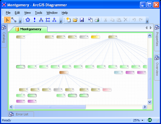
Step 3: Arrange geodatabase objects
All geodatabase objects can be re-arranged to suit your needs. Also, some objects like subtypes, domains and feature classes can be expanded to reveal additional details.

Step 4: Print the Diagram
Before printing or plotting the diagram you may want to specify a printer/plotter and paper size. Click File > Print Setup...

In the Printer Setup dialog select a printer and paper size.

Finally, click File > Print to send the diagram for printing/plotting.

No comments:
Post a Comment